| Area |
Stemple Creek |
| Topic |
Climate: Stemple Creek Estimated Average Monthly Rainfall |
 Click on image to enlarge (126K). Click here to display a larger version (237K).
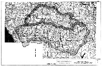
Questa Engineering Corporation performed hydrological studies for the City of Santa Rosa and the U.S. Army Corps of Engineers in the mid-1990s. This map shows the locations where monthly stream flow estimations were determined (Americano Creek at Valley Ford and Stemple Creek at Highway One) using a water balance analysis, as well as the Sonoma County Water Agency rainfall gaging stations (Erikson, Gerritson, and Two Rock) used for this analysis. Map taken from Questa, 1996.
To learn more about this topic click Info Links
To view additional information (data source, aquisition date etc.) about this page, click Metadata
 Click on image to enlarge (126K). Click here to display a larger version (237K).